17. juuli. Erinevalt Palmers Barni asukohast Tavistocki läheduses, kus ümberringi oli ainult maantee ja see väga jooksma ei kutsunud, siis Penzance Backpackersi lähedus merele andis selleks jälle ideaalse võimaluse. Hommikune promenaad oli jooksjatest tühi kuid koeraga jalutajaid oli piisavalt. Ööbimise hinna sees oli hommikusöögiks kerge toit: tee/kohv, röstsai marmelaadi/moosiga. Kuna see tundus veidi kesine, tellisime eelmisel õhtul juurde natuke sisukama kontinentaalse variandi: croissant, sokolaadisaiake, juust ja jogurt.
 |
| St Michael`s Mount |
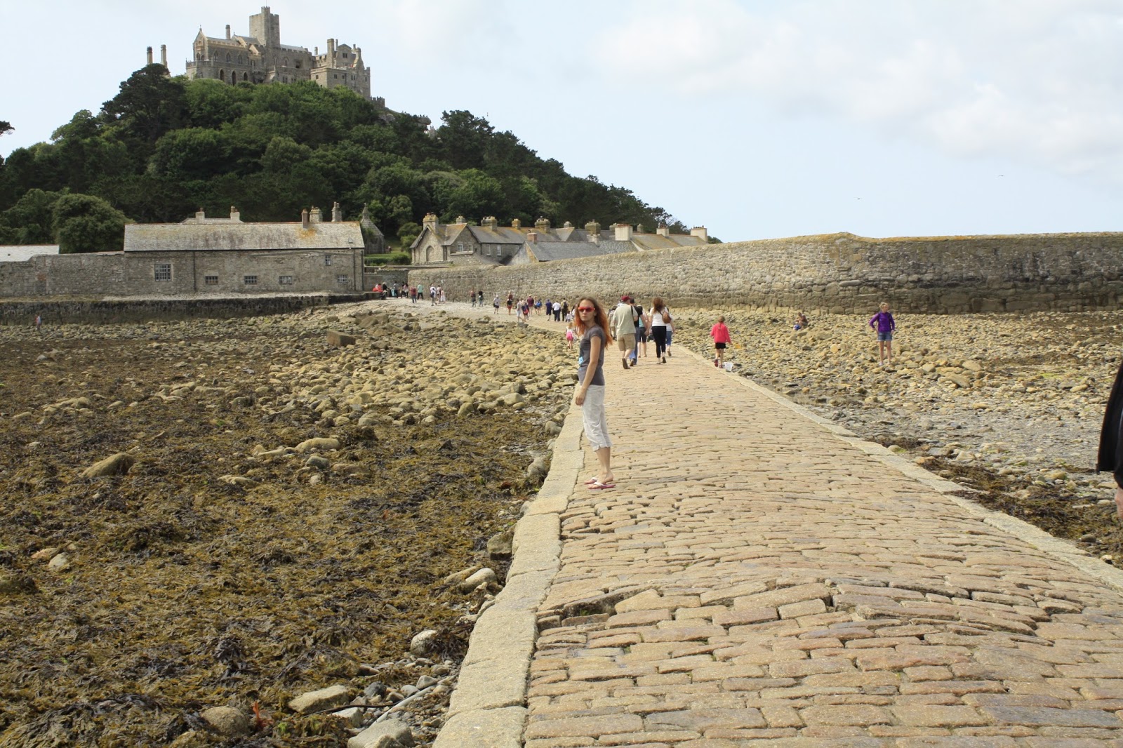
Hommik jätkus lühikese sõiduga
Marazioni. Auto saime jätta suurde parklasse, olime ühed esimestest. Otsustades selle järgi, kui tihedalt parkimiskorraldajad meie auto teiste vahele kohale lubasid, oodati väga suurt hulka külastajaid. Marazion on koht, mille kaudu on võimalik liikuda
St Michael`s Mountile. St Michael`s Mount on tõusu ajal saar, mõõna ajal poolsaar, mida ühendab maismaaga umbes veerand miiline jalgtee.
 |
| Kindlus |
Iirimaa reisil avanes võimalus esimest korda tõusu jälgida. Ainuke kord kui olin Tomist valesti aru saanud ja liiga varase parempöörde teinud, sattusime karavanide randa ajal, mil toimus tõus. Vesi liikus suure jõuga maismaa suunas. Nüüd pidi jalgtee vabanema 10.30ks, sõitsin teadlikult varem kohale, et mõõn samuti üle vaadata. Ema oli kõhkleval seisukohal, kas vesi ikka tõesti jalgtee vabastab või oleks parem paadiga saarele minna. Ilm oli imeilus, jalutasin natuke ringi kuid ülejäänud aja jälgisime vee taandumist. Mõned minutid pärast lubatud aega oli jalgtee vaba.
 |
| St Michael`s Mount, mõõn |
Saarel elab umbes 30 püsielanikku, seal on 4 tänavat ja loomulikult sadam (15. sajandist). Saare tipus ilutseb kindlus, mille südames 12.sajandil ehitatud kirik. Peaaegu veerandi saarest võtab enda alla aed. Tee kindluseni kulges mööda järsku, munakivi teed. Kindlus on vaatajatele avatud samas mahus, mis teisedki lossid/kindlused. Ilus, väike, kompaktne. Tagasitee ajaks maismaale oli mõõn juba täies mahus.
 |
| The Pipers |
Edasine tee kulges Cornwalli ja Inglise maismaa läänepoolsema tipu, Land`s Endi, poole. Enne seda jäid teele kaks kivi,
The Pipers. Samanimeline kividepaar on ka Bodmin Mooril Hurlersite kiviringide läheduses. Google mapilt vaadates oli The Piperseid ümbritsev hekk
nõnna madal, et tundus teostatav vastavalt 4.7 ja 4.2 meetrised kivid lähemalt üle vaadata. Kohapeal selgus järjekordselt, et see mõte ainult mõtteks jäigi. Sellise heki ületamine oleks olnud suur töö ja nõudnuks vist mõnda abivahendit. Samal ajal, kui meie üle heki kivisid uudistasime, peatus üks auto ning uuriti, kas seal on Merry Maidensi kiviring. Populaarne piirkond :) Lõbusad Neitsid tantsivad paarisaja meetri kaugusel.
 |
| The Merry Maidens |
The Merry Maidens kiviring on pärit hilisest kiviajast, koosnedes 19st umbes 1.2 meetri kõrgusest kivist, mis moodustavad peaaegu 24 meetrise läbimõõduga ringi. Põld Neitside ümber oli heina kasvanud, rada kivide juurde ja nende ümber õnneks niidetud. Raja alguses oli väike koht parkimiseks. Legendi järgi on tegemist 19 neitsiga, kes muudeti kiviks tantsimise eest pühapäeval. Sama saatus ootas vilepillipuhujaid (The Pipers), kes neile muusikat mängisid.
 |
| Minack teater |
Minack on eelmise sajandi alguses kaljusse raiutud vabaõhuteater vaatega Atlandi ookeanile. Tee algus The Merry Maidensi juurest tundus piisavalt süütu. Rahulik kulgemine mööda tuttavat rada. Kodus eeltöö tehtud ja parkla koordinaadid otsitud. Teatri juures olid kaks parklat, üks praktiliselt teatri kõrval ja teine mõned sajad meetrid eemal. Loogiline valik oli ju lähem parkimiskoht, või mis?
 |
Vaade Minackist, Porthcurno laht
|
Jõudsime
Porthcurnosse (koht kus Minack asub) kohale, veeresime mööda esimesest suurest parklast (ema vist märkas ka, et: "Näe, parkla on siin" aga minul olid ju lähemad koordinaadid ka) ja pidime paari minuti pärast kohal olema. No ja siis järsku oli minu ees sein. Selline mõnus ühe sõidurealine sein, mille paremale küljele jäi kaljusein ja vasakule vabalangemine. Ei no, mida veel? Üles sõita kannatas teise käiguga (ei olnud esimene ega jäänud viimaseks korraks Cornwallis kui kõrgem käik ei vedanud), terve tee peas mõte, no mis nüüd saab, kui keegi praegu alla tahab sõita?? Nendel tavalistel teedel on selleks taskud. Mõnikord pole pikka aega aga need on siiski olemas.
 |
| Lavastatud etendused |
Sellele teele nina taevapoole seisma jääda ei tundnud kohe mitte ahvatlev. Ja see auto läheb ülesmäge teokiirusel. Aga mingi ime läbi ei juhtunud sellel hetkel teele kedagi vastupidises suunas liikujat. See oli ainuke kord kui ma mõtlesin, et seda teed mööda peab ju alla ka saama :D
Teater ise on kaunis oma kivist ning rohust istmetega, vaade on lummav. Tegemist on aktiivselt tegutseva teatriga, muul ajal külastajatele uudistamiseks avatud.
 |
| Land`s End |
Minacki juurest viis tee kõige kaugemasse punkti,
Land`s End`i. Mis muud, kui üks suur turistilõks, aga see on üks punktidest, mida Germalo 2011 reisil programmis ei olnud. Ainuüksi parkimise eest kasseeriti 5 naela. Suur külastajakeskus, söögikohad, kino. Land`s Endi silt, mille juures pildi tegemise eest raha küsiti ning esimene ja viimane maja. Ning õitsev kanarbik :)
Järgmisena oli plaanis üles leida kolm kivi: Boscawen-Un Stone kiviring, Lanyon Quoit ja Men-an-Tol.
Boscawen-Un Stone on St Buryani lähedal asuv pronksiajast pärit kiviring. See koosneb 19 ellipsikujuliselt asetsevast ning ühest nende keskel olevast kivist. See ring jäi lähedalt nägemata, jõudsime õigesse kohta ja kivid olid kaugustest vaateulatuses kuid tee nendeni kulges üle põllu ja oli natuke liiga pikk.
 |
| Lanyon Quoit |
Lanyon Quoit on umbes pooleteise meetri kõrgune dolmeen. Praegu moodustavad dolmeeni pealmine, 5.5 meetrine ja 12 tonnine, kivi ning kolm kivi, mis seda toestavad. 18. sajandil oli alumisi kive 4 ja ratsanik mahtus pealmise kivi alt läbi ratsutama. Algupärane dolmeen kukkus 1815. aasta tormis ümber ning taastati üheksa aastat hiljem praegusel kujul.
 |
| Men-an-Tol |
Paar minutit sõitu edasi jõudsime
Mên-an-Tol parkimise koordinaatideni.
Seal ootas ees turismibuss.
 |
| Tee tagasi auto juurde |
Tee kivideni, mis olid üllatavalt pisikesed (keskeltläbi 1.2 meetrit kõrged), oli jälle päris pikk. See oli vist üks väheseid kordi rõõmustada turistidega samal ajal objektile jõudmise üle. Nemad tulid just kivide juurest kui meie nende poole liikusime. Google mapist jäi ekslikult meelde, et sihtkoht on teele lähemal. Vahepeal tekkis juba kahtlus, kas oleme õigel teel või oleme äkki õigest kohtast mööda läinud. Õnneks tuli jupikaupa saksa turiste vastu kuni kivideni välja. Men-an-Tol
koosneb kahest seisvast kivist ning nende vahele jäävast auguga kivist. See asub keset nõmme, saatjaks üks tilluke silt, mis võib vabalt märkamata jääda.
 |
| Päikesepaneelid |
Teel majutuspaika Newquays jäi teele huvitava nimega
Hell`s mouth kohvik, millest üle tee jääb kaunis kaljumaastik vaatega ookeanile. Kahjuks oli kohvik meie sinnajõudmise ajaks juba suletud.
 |
| Meie tuba |
Sealt jätkus tee juba
Newquay ja meie majutuskoha poole, milleks seekord oli
The Glendeveor. Lahe parkimiskoht maja taga. Sisse jõudes tervitas meid rõõmsameelselt John, üks The Glendeveori võõrustajaid. Asukoht jäi peaaegu kesklinna. Õhtul käisin jalutamas, leidsin huvitava maja oma privaatsaarel ning jõudsin väikese sadamani.
 |
| Newquay |
 |
| Newquay |
 |
| Newquay |
 |
The Glendeveor
|
17th July. Unlike Palmers Barn`s which was surrounded solely with motorway or fields that did not seem the safest palce to run, Penzance Backpackers was close to promenade. This morning I didn`t meet any joggers but several people walked their dogs.
Our accommodation included light breakfast: tea/coffee, toast, marmalade and jam. As it did not seem enough we had ordered a bit heavier continental meal that included croissant, pain a chocolat, yougurt and cheese.
 |
| St Michael`s Mount |
Our morning continued with a short drive to
Marazion. We were able to leave our car at a huge car park, being one of the earliest to arrive. Considering how closely next to other cars parking enforcement made us park, they were expecting a enormous crowd.
 |
| St Michael`s Mount, the castle |
Marazion connects the main land to
St Michael`s Mount, an island when the tide is in and a (man-made) peninsula when the tide is low. The Mount is connected to Marazion by a man-made causeway that can be walked on.
I was able to watch the high tide in Ireland. It was the only time when I misunderstood Tom`s directions and made a right turn too early and ended up in a caravan park while water was coming towards the mainland with immense force. It was amazing to observe. Now the causeway was supposed to be accessible by 10.30 a.m. We arrived early to actually see water recide. My mother was a bit hesitant not quite believing the causeway will be crossable and maybe we should take the boat instead.
 |
| St Michael`s Mount |
The weather was brilliant, I took a short walk and then we just looked at water. Just a couple of minutes after the promised time the causeway was free.
 |
| The causeway |
The population of St Michael`s Mount is approximately 30, there are four streets and naturally a harbor (15th century). At the heart of the fortress there is a 12th century church. About quarter of the island are the gardens. The track to the fortress was a steep cobblestone road. The castle is open to visitors most of the days during summer but if you want to visit the gardens, they are only open on Thrusdays and Fridays.
|
| The Pipers |
Our road continued towards the most westerly point of mainland Conrnwall and England. Before that we went to find
The Pipers. They share the name with another standing stones in Bodmin Moor, near The Hurlers. Judging form Google map, the hedge surrounding the stones was so low, it was no problem crossing it and have a closer look at the 4.7 and 4.2 metre high stones. But.. But when we reached our coordinates the stones were nowhere to be seen. Naturally the hedges had grown quite a bit in the meanwhile and it would have been stuggle to cross them. At the same time as I was trying to peek over the hedge a car stopped and asked if I was looking at Merry Maidens. Popular area :) Merry Maidens were dancing a few hundred metres away.
 |
| The Merry Maidens |
The Merry Maidens is a late neolithic stone circle that consists of 19 approximately 1.2 metre high stones that form a circle with 24 metre diameter. The field around the Maidens is covered with high hay, fortunately the track leading to the stones is mown. There is a small space for parking.
Legend says that 19 maidens were turned to stone for dancing on a Sunday. The same destiny awaited the two pipers (The Pipers) who played for them.
 |
| Minack theatre |
Minack dates back to the beginning of the previous century. It is an open-air theatre. The road from The Merry Maidens seemed innocent enough. Peaceful ride on familiar road. I had done my homework and found the coordinates for the parking lot. There are two parking lots near the theatre, on virtually next to it and the other a few hundred metres away. The nearer one is a logical choice, don`t you think?
|
| Porthcurno bay |
We reached
Porthcurno (where Minack is located), rolled past the first parking lot (I think my Mom even said: "See, that`s the parking lot" but I had the coordinates to the closer one and she does not like to walk terribly much) and we were supposed to arrive in a couple of minutes. And then I was faced with a wall. This charming wall that had one lane, right side being a cliff and left side free fall. What the carrot? Our car managed to crawl up with second gear (this was not the first nor the last time in Cornwall when I just couldn`t drive with a higher gear). The entire time up it pounded in my head - what if someone wants to drive down right now?? Usually road have pockets for that. Sometimes not in a long time but they are there. Stopping on this wall didn`t seem appealing in the slightest. And this particuar car crawled up any hill at snail`s pace.
|
| Names of the plays directed |
It must have been a miracle but noone wanted to drive down. This was the only time I managed to think that OMG, I have to drive this road again.
The theatre is beautiful with its stone and grass seats. The view is fascinating. It is a working open-air theatre open to visitors during day.
 |
| Land`s End |
 |
| Land`s End |
From Minack, the road led to the most western point in mainland Englad -
Land`s End. It is nothing more than a tourist trap but it was not included in Germalo intenary in 2011. 5 pounds for parking. A huge visitor`s centre, cafes, cinema. A sign stating the place but if you want to take a photo next to it you have to pay. First and last house. And blooming heather :)
Next, we wanted (well, I wanted) to find three stone formations: Boscawen-Un Stone, Lanyon Quoit and Men-an-Tol.
Boscawen-Un Stone is a Bronze age stone circle near St Buryan. It consists of 19 stones that form an ellipse and one stone in the middle. In the end we did not manage to walk up to that, we saw the stones from a distance but the track leading to them was too far and crossed a field.
 |
| Lanyon Quoit |
Lanyon Quoit is a dolmen that is approximately 1.5 metres high. It is made of three upright stones supporting a 5.5 metre long and 12 tonnes heavy capstone. In the 18th century, there were four upright stones and a horseman could drive under the capstone. The original dolmen fell over in a storm in 1815 and was restored nine years later being quite different.
 |
| Men-an-Tol |
 |
| Men-an-Tol & my Mom |
Just a couple of minute`s drive from Lanyon Quoit are the parking coordinates for another stones -
Mên-an-Tol.
Somewhat surprisingly we were greeted by a tourist bus. The path to the stones, that were surprisingly small in scale (about 1.2 metres high) considering for some reason they look enormous from pictures, was rather long.This was one time I was delighted we happened to see an object at the same time as a group of tourists. They were just coming from the stones while we were walking towards them. I had already begun to wonder if we were on the right road, maybe we have passed the stones already. Fortunately the German tourists kept coming right until the stones. Men-an-Tol consists of two standing stones and a stone with a hole in it. It is located in the middle of a moor, accompanied by a tiny sign that could easily be overlooked.
|
| Solar panels |
On our way to Newquay we wanted to visit a cafe with an interesting name -
Hell`s Mouth cafe. On the other side of the road there is a breathtaking view of cliffs and the ocean. Unfortunately we reached the cafe when it was already closed.
 |
| The Glendeveor |
From there we reached
Newquay and our accommodation for the night
The Glendeveor. It has a off street parking. We were greeted by John, once again a cheerful and very helful host. He made us feel welcome. The Glendeveor is located virtually in the city centre. I took an evening walk, found a house on a private island and a tiny harbor.
 |
| Newquay |
 |
| Newquay |


No comments:
Post a Comment